This road is a real gem. The east-west section across the north end of Baker is a good 30 miles of tree-lined sweepers. Once you get to the northeast of Baker, SR 542 gets positively exciting with a succession of steeply-graded, challenging hairpin curves.
The lower elevations of Mount Baker Highway are fairly typical of the Western Cascade foothills. The pavement is fairly smooth, well-constructed asphalt. The road itself is surrounded by stands of immense evergreens up to 10′ across. Most of the sweepers on this section of road are simply marked by arrows, a speed recommendation not being necessary.

Ski Lifts at the foot of Mount Baker

Sitting in front of the ski resort looking east to Shuksan
The higher elevations of the Mount Baker Highway are highly reminiscent of the photos I’ve seen of the European Alps. There’s extremely tight hairpins with very steep straights in between, in a way that most Americans riders are probably unfamiliar with.
Fortunately for future rides, the roadway up to Artists Point from the Ski Resort was just repaved this year, albeit rather bizarrely completed just a week and change before the closure of Artists Point for the season due to icing conditions.
One of the drawbacks to Mount Baker Highway is that it is a dead-end. After the last services at Maple Falls, 542 exists only as a recreational roadway. The road passes many little resorts and campgrounds, but ultimately exists only to provide access to the ski slopes and visitor’s centers near the peak.
That having been said, the view from Artist’s Point is truly fantastic. As shown here, you can see both Baker and Mt. Shuksan from the parking lot. This is one trip I’m going to have to repeat come spring, with some more serious photographic equipment.

Mount Shuksan and a hairpin turn
Mount Shuksan off to the east. Also pictured is one of several hairpins that we rode to Artists Point. It looks pretty easy due to foreshortening, but the pavement was quite dewy in the shaded sections and oil from the very recent paving job made the ride to the top very nerve-wracking with both tires sliding mid-turn at quite low speeds.
Odd Notes and Tech Data:
- Gas Station to Artist’s Point & back: 70 miles
- 11.7 miles from Kendall to the border crossing in Sumas
- 5.9 miles due north from Kendall to the US-Canadian border
Vital Statistics:
- Towns: Deming, Kendall, Maple Falls, Warnick
- Length: 42 miles (84 round-trip)
- County: Whatcom
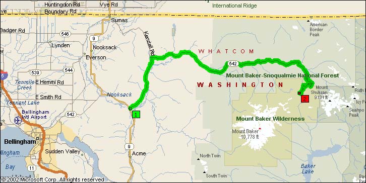
Overview Map of Mt. Baker Highway:
Google map: